Devils Postpile National Monument

Devils Postpile National Monument

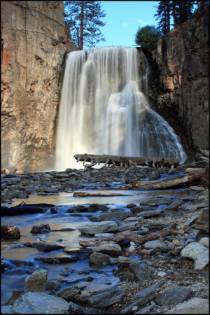
Rainbow Falls
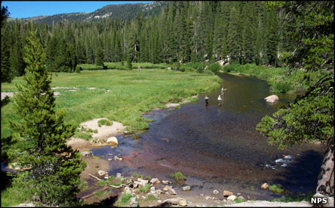
Devils Postpile National Monument is an almost 800-acre property in the central Sierra Nevada Mountains of California. This is an area that sees an average annual snowfall in excess of 400 inches. That means excellent water flows in the San Joaquin River that drains virtually the entire area. The San Joaquin is also a designated Wild Trout Water and with a proper California fishing license, anglers can keep up to five fish per day.
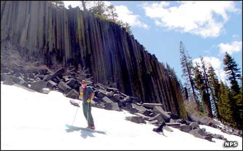
Devils Postpile itself is the product of volcanic and glacial activity: about 80,000 to 100,000 years ago, a lava vent began spewing hot basaltic lava a few miles north of today's monument. That lava was hotter and less viscous than most lava and flowed downhill like a river until it hit a gravel dam, most likely a glacial moraine left behind when the glacier melted away. The lava filled the valley behind the dam to a depth of about 400 feet in some areas. Then the lava cooled slowly and, as it cooled, it cracked. As it cooled it also contracted and formed joints along those cracks. The atomic composition of the basaltic materials is what caused the lava to contract into the primarily hexagonal columns we see today. Those columns originally formed underground but have been exposed over thousands of years by the erosive forces of wind and water but more particularly, the forces of glaciation. It took the strong influence of heavy glaciation to expose the straight columns we see today as those would have been formed more in the middle of the original lava flow 80,000 years ago. There have been several periods of heavy glaciation since then, the last one ending about 15,000 years ago. The upper parts of the columns still show signs of glacial scratching and polishing.
About 2.5 miles hike from the Ranger Station you'll find the aptly named Rainbow Falls, a 101-foot drop on the Middle Fork of the San Joaquin. The falls are in full splendor usually until about July 4, then the flow starts to diminish as the volume of snowmelt begins to diminish. Altogether, there are about 8 miles of trails in Devils Postpile National Monument and many of them feed to trails on Inyo National Forest that head into either the Ansel Adams or John Muir Wilderness areas.
Originally, Devils Postpile was part of Yosemite National Park but the discovery of gold near Mammoth Lakes in 1905 caused a change in the park's boundaries to allow the miners to do their thing in their own way. Then someone started pushing to build a hydroelectric dam on the San Joaquin River and blasting the postpile into the river as part of that project... John Muir and other prominent Californians lobbied Congress and the president's office until President William Howard Taft protected the area as a National Monument in 1911.
Devils Postpile is only open during the summer months because of usually heavy snowfall in the area. Usual opening date is in mid-June and snow starts falling again in mid to late October. When the monument is open, it's open 24 hours a day, 7 days a week until the gates are forced to close by snow. Once the monument is open, the ranger station is open from 9 am to 5 pm daily until Labor Day, then hours start to vary through September and October until the monument closes for the winter. The Devils Postpile Campground usually opens in late June and stays open until September 15. All monument trails and day use areas are open until the monument closes for the season. Once the road closes, hiking on the property is allowed but no services are available and no vehicles are allowed.
The best time to visit Devils Postpile is in late June before the crowds start to arrive around July 4th. It's a good time to visit after Labor Day, too, as the colors tend to peak in late September, early October. The usual plan is for the monument to be open until Halloween but winter storms often force the gates closed earlier than that. Between July 4 and Labor Day, expect the trails to be busy, the campground to be full and access to the monument to be only available via the shuttle bus from Mammoth Lakes. The waterfalls tend to be really full well into July, then start to diminish. August is typically the warmest and busiest month of the year, then Labor Day signals the last of the big crowds.
Many folks use the Devils Postpile area as a starting point for trips into the Ansel Adams and John Muir Wilderness areas in Inyo National Forest. Overnight trips require possession of a permit. Staff at Devils Postpile can issue those permits but it's best if folks could go directly to an actual Info National Forest permit office or to the Mammoth Lakes Welcome Center. Those offices will also more likely have up-to-date info about the trails and weather conditions.

Minaret Falls
The Reds Meadow Shuttle Bus provides service from Mammoth Lakes to Reds Meadow Valley and Devils Postpile from 7 am to 7 pm daily during the summer season.
The Devils Postpile Campground offers 21 sites, first-come, first-served. No reservations are available. Folks going camping are exempt from the shuttle bus requirement and can drive in, pay the fees and go camp. Camping fee is in addition to the standard amenity/entry fee.
The campground offers running water and flush toilets. Each site has a firepit, picnic table and bear-proof metal locker. There are no showers or RV hookups. In addition, very few of the campsites can accommodate any vehicles longer than 25 feet. The campground loops are so tight that moving anything larger is also very demanding. Campsites are limited to six people per site per night and two vehicles. Extra vehicles can be parked at the overflow lot just outside the monument boundary. The stay limit is 14 days.
There are several campgrounds in the Reds Meadow Valley of Inyo National Forest, just outside the National Monument. Campsites there are similarly equipped, see similar traffic and cost $20 per site per night.

A late season skier at Devils Postpile National Monument

Anglers working the San Joaquin River
Photo of Rainbow Falls courtesy of Frank Kovalchek, CCA 2.0 License
Other photos and map courtesy of the National Park Service