White River Scenic Road

White River Scenic Road is an eleven-mile route along Arizona Highway 73 beside the White River, wholly contained within the environs of the Fort Apache Indian Reservation.
From Pinetop-Lakeside, the White River Scenic Road travels down off the top of the Mogollon Rim into Hon Dah, then follows the North Fork of the White River down to the town of Whiteriver, capital of the Fort Apache Nation. This is a descent from Ponderosa pine and fir forest into the upper reaches of the Sonoran Desert through canyons eroded into the edge of the Colorado Plateau over the last 65 million years.
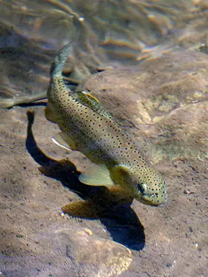
Just below Hon Dah is a road leading east to the Williams Creek National Fish Hatchery. Williams Creek has been instrumental in bringing the endangered Apache trout back from the brink of extinction. The trout are birthed at Williams Creek, then released down the stream to holding pens at Alchesay Station where they are grown to a size large enough to be moved to more natural surroundings on Indian Reservations scattered all across the southwestern states.

Kinishba Ruin
Kinishba is an ancient pueblo site just west of Fort Apache. Excavations have revealed that the people who built the pueblo were a mix of cultures: prehistoric Mogollon and Anasazi. The mix is indicated in their style of architecture, methods of construction and in the manufacture and design of pottery and other remains they left behind. The site is listed on the National Register of Historic Places and is under the care of the Fort Apache Nation. Clans from both the Zuni and Hopi tribes trace their ancestral roots back to Kinishba.
Photo of Kinishba Ruins courtesy of the National Park Service
Photo of the Apache trout courtesy of the US Forest Service
