Sonoran Desert National Monument

Typical view on the Sonoran Desert National Monument

The Sonoran Desert National Monument came into being about ten years after the three national wilderness areas on the monument were designated. Taking up about 487,000 acres of the most biologically diverse desert landscape in North America, the Sonoran Desert National Monument fulfills one of the missions of the Bureau of Land Management: to preserve and protect precious natural resources so that our children and their children may be able to enjoy them.
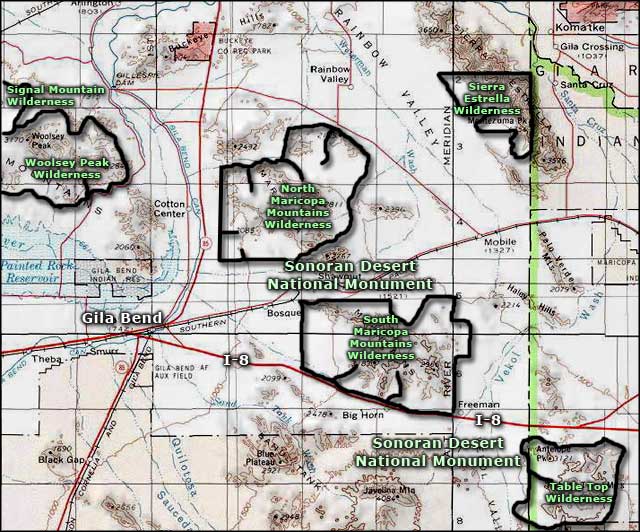
This area of the Sonoran Desert is characterized by large, dense forests of giant saguaro cacti interspersed with paloverde trees, ironwood, mesquite, cholla, ocotillo and many, many wildflowers. Within the boundaries of the national monument are the Table Top, Sand Tank and Maricopa Mountains. Also among the wide valleys are the Booth and White Hills and several significant archaeological and historic sites. The Juan Bautista de Anza National Historic Trail also crosses the property on its journey between Tubac, Arizona and Monterey, California. The de Anza Trail parallels the old Butterfield Overland Stage Route, the Gila Trail and the Mormon Battalion Trail. The 10-mile-long trail corridor across the national monument can be driven (in good weather, of course) by 4WD with high clearance.
To get there: go to Gila Bend. From the east side of Gila Bend take Arizona Highway 238 east for about four miles to the western boundary of the national monument. Or, go to Maricopa and head west on Arizona Highway 238 for about 16 miles to the eastern boundary of the national monument. To access the Table Top area of Sonoran Desert National Monument, take Interstate 8 to Vekol Road, get off and continue south on Vekol Road. The Sand Tank Mountains (south of Interstate 8) require a permit for legal access.

On Sonoran Desert National Monument, motorized and mechanized vehicles (including bicycles) must remain on existing routes and are not allowed in the wilderness areas. The wilderness areas are for foot and horseback travel only. Winter is the best time to visit because summer time cooks... literally. It's hot enough in February for the rattlesnakes and scorpions to be out and about. Rainy season is not a good time to get caught on this property: flash floods are common and can be dangerous. Before visiting the back country you might want to call the BLM office at the number below and check out the road conditions.
There are no developed camping facilities on the Sonoran Desert National Monument. Primitive camping is allowed virtually everywhere. There is no drinking water available and no services of any kind on the property. If you want to go exploring here, bring plenty of food and water, a good compass or GPS device, good maps, a full tank of gas and maybe even an extra full-size spare tire. Forget the cell phone at home: they are usually only good for paperweights on this property.
Photos courtesy of the Bureau of Land Management
